Walkway of the Gods: A Comprehensive Guide to the Satopanth Tal Trek
There are ordinary Himalayan treks that reward you with beautiful ridges, and then there is the Satopanth Tal Trek—a raw, high-altitude expedition wrapped deeply in ancient Vedic mythology.
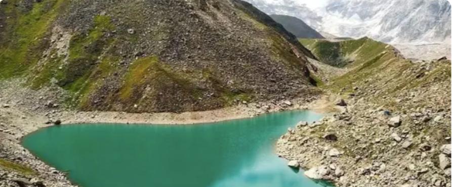
Tucked away in the Chamoli district of Uttarakhand near Badrinath, Satopanth Tal is a flawless, emerald-green, triangular glacial lake sitting at an imposing altitude of 4,600 meters. The name itself translates to the "Path of Truth".
If you are looking to graduate from moderate hiking to a true, crowd-free Himalayan expedition, here is your definitive blog guide to conquering the Satopanth Tal trail.
The Mythological Allure
For the locals and spiritually inclined trekkers, Satopanth is not just a destination; it is a pilgrimage.
The Holy Trinity: According to Hindu scripture, the three corners of this triangular lake are occupied by the holy trinity—Brahma, Vishnu, and Maheshwara (Shiva)—who meditated here.
The Stairway to Heaven: This is the exact route the five Pandavas and Draupadi took on their final journey to the cosmos (Swargarohini Yatra). Legends say that one by one, they gave up their mortal bodies along this harsh trail, and only Yudhishthira, accompanied by a mystical dog, successfully ascended the final peak.
Trek Overview
FeatureDetailsAltitude$4,600\text{ meters}$ ($15,100\text{ feet}$)Difficulty LevelModerate to DifficultTotal DistanceApproximately $46\text{ km} - 50\text{ km}$ (Round-trip)Duration6 to 7 Days (Excluding travel from Rishikesh)Best TimeMay to mid-July (Summer) & September to October (Autumn)Base CampMana Village (The last village of India)
Detailed Day-by-Day Itinerary
Day 1: Drive from Rishikesh to Badrinath (300 km / 10 hours)
The adventure begins with a long, dramatic drive tracking the Alaknanda River upstream. You will cross the famous Prayags (confluences)—Devprayag, Rudraprayag, and Karnaprayag. Arrive at the holy town of Badrinath ($10,800\text{ ft}$) by evening. Use this night to rest, visit the Badrinath Temple, and begin your critical altitude acclimatization.
Day 2: Badrinath to Laxmi Van via Mana Village (8 km trek / 5 hours)
Take a short 3 km drive to Mana, the last Indian village before the Indo-Tibetan border. The actual foot-trail starts here along the left bank of the Alaknanda River.
Highlights: Pass through Bhim Pul (a massive natural rock bridge) and catch spectacular views of the $400\text{ ft}$ roaring Vasudhara Falls.
Campsite: Laxmi Van ($11,800\text{ ft}$), a serene patch surrounded by birch tree forests and towering mountain walls.
Day 3: Laxmi Van to Chakrateertha (7 km trek / 6 hours)
The lush meadows start fading away, replaced by the harsh reality of glacial moraines. You will navigate steep ascents over rocky terrain and lateral moraines of the Dhano Glacier.
The Views: The mighty Mt. Neelkanth, Balakun, and Chaukhamba peaks begin to dominate the horizon, feeling so close you could almost touch them.
Campsite: Chakrateertha ($13,500\text{ ft}$), a vast, cold alpine meadow where mythology says Lord Vishnu’s Sudarshan Chakra fell.
Day 4: Chakrateertha to Satopanth Tal and back to Chakrateertha (11 km / 7-8 hours)
The Summit Day. You will need an early start ($5:00\text{ AM}$). The trail is entirely over loose scree, boulders, and steep labyrinthine ridges of the glacier.
As you top the final ridge, the stark, rocky wilderness gives way to the breathtaking sight of Satopanth Tal. The crystal-clear, emerald water stands in pin-drop silence, perfectly mirroring the towering Swargarohini steps right behind it. Spend an hour soaking in the immense, meditative energy of the lake before carefully tracing your steps back down to Chakrateertha for the night.
Day 5 & 6: Retracing Steps to Mana/Badrinath & Return to Rishikesh
The descent is swift but requires focus to avoid twisting ankles on the loose moraine rocks. You will trek back to Mana village, take a cab to Badrinath, and spend the final day driving back down to the vibrant cafes of Rishikesh to celebrate your successful expedition.
When to Pack Your Bags?
Summer (May to Mid-July): The weather is pleasant ($12^\circ\text{C}$ to $15^\circ\text{C}$ in the day, dropping to $-5^\circ\text{C}$ at night). You will find alpine flowers blooming and crisp blue skies, making it perfect for photography.
Post-Monsoon/Autumn (September to October): The monsoon completely clears the atmosphere. Skies are exceptionally clear, and by October, light dustings of fresh snow carpet the moraines. Be prepared for freezing nights dropping to $-15^\circ\text{C}$.
Avoid Monsoons (Late July to August): The route to Badrinath is highly prone to severe landslides, and walking over wet glacial moraine is dangerously slippery.
Fitness & Technicality: Can You Do It?
Satopanth Tal does not require technical mountaineering gear like ropes or ice axes, but it is not a trek for beginners.
The terrain is notoriously unforgiving—you will be walking for hours over boulder-strewn glaciers where a single misplaced step can roll an ankle. Furthermore, gaining an altitude of $15,100\text{ ft}$ increases the risk of Acute Mountain Sickness (AMS).
Training Blueprint:
To safely enjoy this trek, you should start preparation 1–2 months prior:
Cardiovascular training (running $5\text{ km}$ under 30 minutes).
Leg endurance (weighted squats, lunges, and stair-climbing).
Consistent hydration and prior experience on at least one moderate $4,000\text{m}+$ Himalayan trek.
Quick Insider Tips
Cleanliness Legend: Local folklore states that mystical birds (Gandharvas in disguise) pick up any stray leaves or trash that falls into Satopanth Tal to keep it pristine. Do your part—leave absolutely no footprint or plastic behind.
Inner Line Permits: Because of its proximity to the international border, you will need authorised trekking permits and a registered local guide to pass the forest checkposts at Mana.
No Charging: Mana village is your final point with electricity. Pack high-capacity power banks and keep your camera batteries warm inside your sleeping bag at night so they don't drain.
Would you like advice on the specific permits and paperwork required for this region, or perhaps a breakdown of the essential gear to pack for the freezing temperatures?