Sitting at an intimidating altitude of $4,950\text{ m}$ ($16,240\text{ ft}$)., Bali Pass represents the ultimate evolution from trekking into serious mountaineering terrain, offering a cocktail of deep pine forests, vast alpine meadows (bugyals), high-altitude glacial lakes, and a heart-pounding ridge walk on snow and ice.
The Trail & Core Highlights
1. The Tale of Two Valleys
The defining beauty of a crossover pass like Bali Pass is the dramatic transformation of the landscape.
The Ascent (Har Ki Dun side): Follows the gushing Tons River through ancient wooden villages like Osla and Seema, winding through thick forests of blue pine, chestnut, and cedar. It eventually opens up into the massive meadows of Devsu Thach.
The Descent (Yamunotri side): Once you cross the knife-edge pass, the terrain drops sharply into a stark, scree-heavy, and glaciated world, eventually leading you straight to the sacred shrines of the Yamunotri glacier basin (Kuniyal, 2025).
2. Ruinsara Tal: The Sacred Glacial Lake
Located at $3,500\text{ m}$, this pristine, bone-chillingly cold lake is a major spiritual and geographical landmark on the route. Encircled by alpine rhododendrons and towering peaks, it is steeped in local mythology (associated with the Pandavas) and serves as a vital acclimatization stop before hitting the advanced snow camps of Odari and Bali Udari.
3. Intimidating Amphitheater of Peaks
The summit ridge of Bali Pass grants a panoramic look at some of the most prominent massifs in the Garhwal region. Trekkers get a dizzyingly close, front-row view of:
Swargarohini I, II, and III
Bandarpunch Massif
Kalanag (Black Peak)
The Crux: Why Bali Pass is a Formidable Challenge
Bali Pass is not a regular trekking trail; it requires strong physical conditioning, mental resilience, and, ideally, previous high-altitude experience (such as Roopkund, Hampta Pass, or Rupin Pass).
The Knife-Edge Ridge Walk: The final approach to the pass involves walking along a very narrow, exposed snow ridge where the wind can howl fiercely. Footholds must be precise.
The Technical Descent: Dropping down from the pass toward the Yamunotri side is notorious for its steepness. Trekkers often have to navigate a near-vertical slope ($50\text{--}60^\circ$ incline) composed of loose scree, boulders, or hard-packed ice. Depending on the season, microspikes, crampons, or even fixed ropes are deployed by guides to ensure safety.
The "Odari" Camp: Named after a giant rock cave (Odari means cave in the local dialect), this campsite sits at nearly $4,100\text{ m}$ and serves as the launchpad for the summit push. Surviving the freezing night temperatures here tests a trekker’s cold-weather endurance.
Standard Itinerary Outline
A typical route maps out across 7 to 8 days to allow for safe, incremental acclimatization:
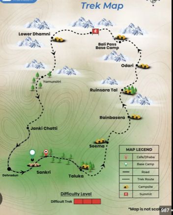
Day 1: Drive from Dehradun to Sankri ($1,950\text{ m}$) — The bustling hub for Garhwal treks.
Day 2: Drive from Sankri to Taluka; Trek to Seema/Osla ($2,560\text{ m}$) via dense forests.
Day 3: Trek from Seema to Devsu Thach ($3,000\text{ m}$) — A stunning meadow campsite.
Day 4: Trek from Devsu Thach to Ruinsara Tal ($3,500\text{ m}$) — Glacial lake exploration.
Day 5: Trek from Ruinsara Tal to Odari ($4,100\text{ m}$) — Steep climb into the alpine zone.
Day 6: Odari to Bali Pass Summit ($4,950\text{ m}$) and descend down to Upper Dhamni / Bali Udari($3,600\text{ m}$) — The grueling, technical 10–12 hour summit day.
Day 7: Upper Dhamni to Janki Chatti ($2,650\text{ m}$) via the Yamunotri Temple shrine (Kuniyal, 2025) $\rightarrow$ Drive back to Dehradun.
Pro-Tip for Trekkers:
If attempting this in early summer (May–June), expect a massive volume of snow, which makes the descent fun but requires excellent technical gear like gaiters and ice axes. If attempting post-monsoon (September–October), the snow recedes, exposing bare rock and loose scree, making the descent a test of knee stability and balance.
Would you like to explore the specific technical gear list required for the pass, or dive deeper into the physical training regimen needed to handle a high-altitude climb of this scale?