There is a distinct moment on every Himalayan trek where the dense forest canopy abruptly breaks, and you are forced to stop dead in your tracks. On the Dayara Bugyal trek in Uttarakhand, that moment doesn’t just offer a viewpoint—it opens up into a massive, rolling ocean of green meadows that feels entirely cut off from the chaotic world below.
In the local Garhwali dialect, “Bugyal” translates directly to a high-altitude alpine pastureland. Spanning over 28 square kilometers at an elevation scaling up to 12,400 feet, Dayara is widely considered one of the most expansive and visually stunning meadows in Asia.
Whether you're a beginner looking for a gentle introduction to high-altitude wilderness or a seasoned trekker seeking an expansive mountain view, here is a complete layout and guide to this Himalayan wonderland.
Why Dayara Bugyal Belongs on Your Map
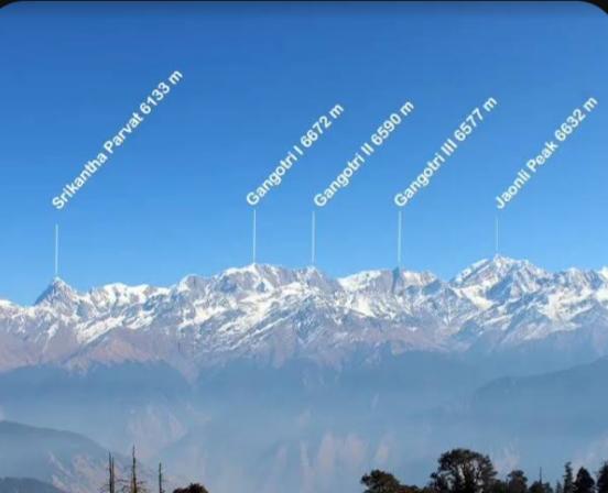
The Colossal Mountain Wall: The meadows serve as a giant, front-row balcony to a towering array of snow-capped peaks. Looking closely at the horizon, you get clear sightlines to the Gangotri Massif (I, II, and III), Srikantha Parvat, and Jaonli Peak.
A Four-Season Chameleon: Unlike trails that completely close in the winter, Dayara is a true year-round destination. Spring brings bright pink and red rhododendrons; summer offers lush green carpets; autumn delivers crisp, golden-brown vistas; and winter transforms the rolling mounds into a deep-powder skiing playground.
The "Butter Holi" (Anduri Utsav): If you time your visit for mid-August, you can witness a beautiful cultural quirk. Local villagers move up to the meadows to celebrate the Anduri Utsav, playing Holi using fresh butter, milk, and buttermilk as a thank-you to the mountains for protecting their grazing cattle.
The Classic 4-Day Route BlueprintMost trekkers choose the scenic village of Raithal as their base camp. The trail ascends gradually, ensuring plenty of time to acclimatise while walking through fairytale forests of silver oak and ancient maples.
1
Dehradun to Raithal Village
Drive: 180 km | 7-8 hours
The journey starts with a mountain drive winding alongside the Bhagirathi River. Arrive at the heritage village of Raithal (7,423 ft), where you can stay in local homestays, explore traditional wooden architecture, and rest up.
2
Raithal to Gui Campsite
Trek: 5 km | 4-5 hours
Step onto the trail through dense oak forests. The climb is a gradual, steady incline. You'll emerge at the pristine Gui Campsite, a beautiful clearing featuring small alpine ponds and clear views of the striking Srikantha peak.
3
Gui to Dayara Top & Back
Trek: 12 km | 7-8 hours
The big summit day! The forest thins out rapidly into the massive, rolling expanses of the actual Dayara Bugyal. Push further up the ridge to Bakariya Top (~12,400 ft) for a majestic 360-degree theater of snow-capped peaks before heading back down to Gui to camp.
4
Gui to Raithal & Dehradun
Trek: 5 km | Drive: 180 km
Enjoy a swift, morning downhill trek back through the woods to Raithal village. Celebrate your successful trek with a warm local meal before hopping into your vehicle for the return drive to Dehradun.
Trek Essentials at a Glance:Starting Point: Raithal or Barsu (near Uttarkashi, Uttarakhand)
Total Distance: Approximately 22 km (Round trip)
Highest Altitude: 12,400 feet (Bakariya Top)
Difficulty Level: Easy to Moderate (Perfect for beginners & families)
Best Seasons: Spring (March to May) for alpine blooms, or Winter (December to February) for deep snow landscapes